|
|
|||||||||||||||||
| Point ID: 8632 | Downloads | Plots | Site Data | Code: 11307 |
|
|
|||||||||||||||||
| Download | |
|---|---|
| Site Descriptor Information | Site Time Series Data |
| Link to all available data | |
| View: | Time Series | All |
| Units: | m3/s |
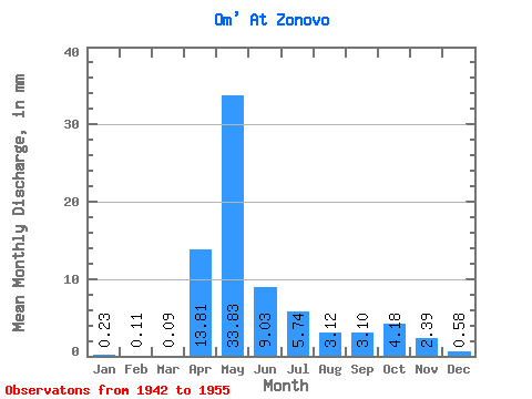
| Statistic | Jan | Feb | Mar | Apr | May | Jun | Jul | Aug | Sep | Oct | Nov | Dec | Annual |
|---|---|---|---|---|---|---|---|---|---|---|---|---|---|
| Mean | 0.23 | 0.11 | 0.09 | 13.81 | 33.82 | 9.03 | 5.74 | 3.12 | 3.10 | 4.18 | 2.39 | 0.58 | 75.76 |
| Standard Deviation | 0.22 | 0.10 | 0.08 | 13.97 | 27.36 | 8.13 | 5.98 | 3.67 | 3.34 | 4.59 | 2.85 | 0.86 | 53.71 |
| Min | 0.04 | 0.02 | 0.01 | 0.51 | 10.05 | 0.60 | 0.14 | 0.08 | 0.04 | 0.07 | 0.06 | 0.05 | 16.48 |
| Max | 0.79 | 0.37 | 0.27 | 53.19 | 94.43 | 25.16 | 19.07 | 13.33 | 11.46 | 14.06 | 7.49 | 3.22 | 164.50 |
| Coefficient of Variation | 0.96 | 0.92 | 0.89 | 1.01 | 0.81 | 0.90 | 1.04 | 1.18 | 1.08 | 1.10 | 1.19 | 1.48 | 0.71 |
 Return to R-Arctic Net Home Page