|
|
|||||||||||||||||
| Point ID: 8626 | Downloads | Plots | Site Data | Code: 11284 |
|
|
|||||||||||||||||
| Download | |
|---|---|
| Site Descriptor Information | Site Time Series Data |
| Link to all available data | |
| View: | Time Series | All |
| Units: | m3/s |
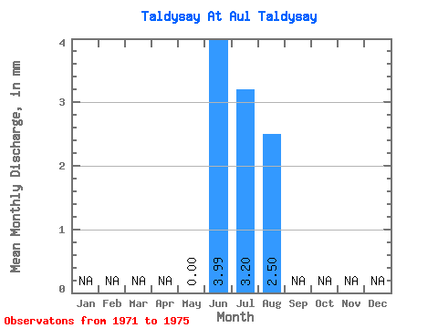
| Statistic | Jan | Feb | Mar | Apr | May | Jun | Jul | Aug | Sep | Oct | Nov | Dec | Annual |
|---|---|---|---|---|---|---|---|---|---|---|---|---|---|
| Mean | 0.00 | 3.99 | 3.20 | 2.50 | |||||||||
| Standard Deviation | 0.00 | 2.70 | 2.35 | 2.60 | |||||||||
| Min | 0.00 | 0.47 | 0.43 | 0.13 | |||||||||
| Max | 0.00 | 6.47 | 6.29 | 6.07 | |||||||||
| Coefficient of Variation | 0.68 | 0.73 | 1.04 |
 Return to R-Arctic Net Home Page