|
|
|||||||||||||||||
| Point ID: 8624 | Downloads | Plots | Site Data | Code: 11277 |
|
|
|||||||||||||||||
| Download | |
|---|---|
| Site Descriptor Information | Site Time Series Data |
| Link to all available data | |
| View: | Time Series | All |
| Units: | m3/s |
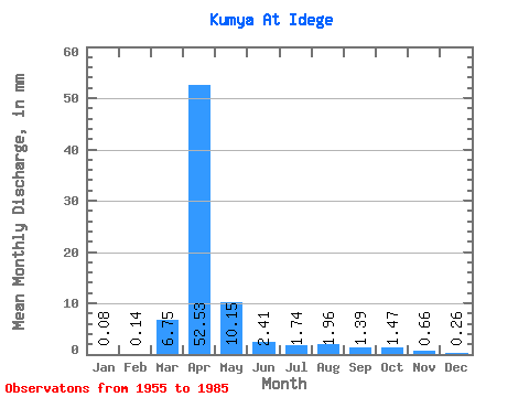
| Statistic | Jan | Feb | Mar | Apr | May | Jun | Jul | Aug | Sep | Oct | Nov | Dec | Annual |
|---|---|---|---|---|---|---|---|---|---|---|---|---|---|
| Mean | 0.09 | 0.12 | 6.76 | 52.54 | 10.14 | 2.42 | 1.73 | 1.96 | 1.37 | 1.49 | 0.66 | 0.26 | 66.41 |
| Standard Deviation | 0.27 | 0.43 | 15.55 | 52.29 | 10.70 | 3.69 | 1.47 | 3.31 | 1.39 | 1.25 | 0.57 | 0.41 | 35.77 |
| Min | 0.00 | 0.00 | 0.00 | 5.11 | 0.87 | 0.11 | 0.00 | 0.00 | 0.00 | 0.00 | 0.00 | 0.00 | 14.00 |
| Max | 0.98 | 1.82 | 57.33 | 250.44 | 40.38 | 17.89 | 7.17 | 18.48 | 7.67 | 5.66 | 1.72 | 1.21 | 124.94 |
| Coefficient of Variation | 3.05 | 3.50 | 2.30 | 0.99 | 1.05 | 1.53 | 0.85 | 1.69 | 1.01 | 0.84 | 0.87 | 1.61 | 0.54 |
 Return to R-Arctic Net Home Page