|
|
|||||||||||||||||
| Point ID: 8610 | Downloads | Plots | Site Data | Code: 11225 |
|
|
|||||||||||||||||
| Download | |
|---|---|
| Site Descriptor Information | Site Time Series Data |
| Link to all available data | |
| View: | Time Series | All |
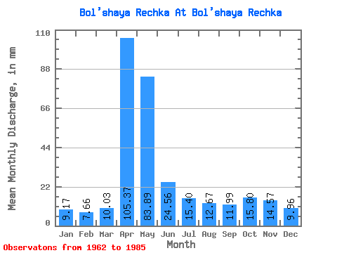
| Units: | m3/s |
| Statistic | Jan | Feb | Mar | Apr | May | Jun | Jul | Aug | Sep | Oct | Nov | Dec | Annual |
|---|---|---|---|---|---|---|---|---|---|---|---|---|---|
| Mean | 9.17 | 7.72 | 10.03 | 105.37 | 83.88 | 24.56 | 15.39 | 12.67 | 11.99 | 15.80 | 14.57 | 9.96 | 323.26 |
| Standard Deviation | 1.80 | 1.56 | 3.62 | 36.00 | 49.82 | 11.73 | 6.22 | 3.99 | 2.93 | 4.35 | 4.97 | 2.51 | 83.22 |
| Min | 6.12 | 4.75 | 4.71 | 35.43 | 24.27 | 10.58 | 6.82 | 6.52 | 7.77 | 8.12 | 6.99 | 5.12 | 185.38 |
| Max | 12.04 | 10.60 | 21.46 | 187.36 | 206.62 | 53.10 | 30.89 | 21.36 | 18.45 | 25.78 | 25.43 | 15.25 | 513.29 |
| Coefficient of Variation | 0.20 | 0.20 | 0.36 | 0.34 | 0.59 | 0.48 | 0.40 | 0.32 | 0.24 | 0.28 | 0.34 | 0.25 | 0.26 |
 Return to R-Arctic Net Home Page