|
|
|||||||||||||||||
| Point ID: 8607 | Downloads | Plots | Site Data | Code: 11222 |
|
|
|||||||||||||||||
| Download | |
|---|---|
| Site Descriptor Information | Site Time Series Data |
| Link to all available data | |
| View: | Time Series | All |
| Units: | m3/s |
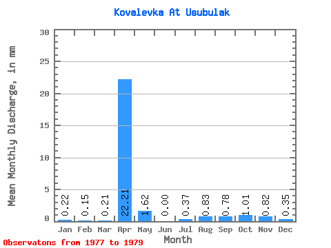
| Statistic | Jan | Feb | Mar | Apr | May | Jun | Jul | Aug | Sep | Oct | Nov | Dec | Annual |
|---|---|---|---|---|---|---|---|---|---|---|---|---|---|
| Mean | 0.22 | 0.16 | 0.21 | 22.21 | 1.62 | 0.00 | 0.37 | 0.83 | 0.78 | 1.01 | 0.82 | 0.36 | |
| Standard Deviation | 0.31 | 0.22 | 0.30 | 0.44 | 0.52 | 0.22 | 0.22 | 0.07 | 0.22 | ||||
| Min | 0.00 | 0.00 | 0.00 | 21.91 | 1.62 | 0.00 | 0.00 | 0.83 | 0.53 | 0.88 | 0.77 | 0.20 | |
| Max | 0.44 | 0.31 | 0.42 | 22.52 | 1.62 | 0.00 | 0.74 | 0.83 | 0.96 | 1.26 | 0.87 | 0.51 | |
| Coefficient of Variation | 1.41 | 1.41 | 1.41 | 0.02 | 1.41 | 0.28 | 0.21 | 0.09 | 0.63 |
 Return to R-Arctic Net Home Page