|
|
|||||||||||||||||
| Point ID: 8596 | Downloads | Plots | Site Data | Code: 11185 |
|
|
|||||||||||||||||
| Download | |
|---|---|
| Site Descriptor Information | Site Time Series Data |
| Link to all available data | |
| View: | Time Series | All |
| Units: | m3/s |
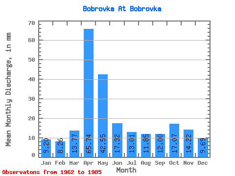
| Statistic | Jan | Feb | Mar | Apr | May | Jun | Jul | Aug | Sep | Oct | Nov | Dec | Annual |
|---|---|---|---|---|---|---|---|---|---|---|---|---|---|
| Mean | 9.20 | 8.34 | 13.78 | 65.75 | 42.54 | 17.32 | 13.01 | 11.86 | 11.99 | 17.07 | 14.22 | 9.70 | 234.92 |
| Standard Deviation | 3.36 | 2.55 | 9.32 | 25.54 | 28.50 | 7.82 | 5.50 | 5.03 | 4.17 | 6.32 | 5.35 | 3.16 | 68.82 |
| Min | 4.27 | 4.32 | 5.45 | 23.40 | 13.27 | 7.34 | 4.98 | 4.03 | 4.13 | 2.56 | 5.50 | 4.98 | 123.12 |
| Max | 17.77 | 14.47 | 51.43 | 112.17 | 135.56 | 37.62 | 25.83 | 24.88 | 20.41 | 30.34 | 24.77 | 17.06 | 399.15 |
| Coefficient of Variation | 0.36 | 0.30 | 0.68 | 0.39 | 0.67 | 0.45 | 0.42 | 0.42 | 0.35 | 0.37 | 0.38 | 0.33 | 0.29 |
 Return to R-Arctic Net Home Page