|
|
|||||||||||||||||
| Point ID: 8584 | Downloads | Plots | Site Data | Code: 11167 |
|
|
|||||||||||||||||
| Download | |
|---|---|
| Site Descriptor Information | Site Time Series Data |
| Link to all available data | |
| View: | Time Series | All |
| Units: | m3/s |
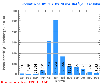
| Statistic | Jan | Feb | Mar | Apr | May | Jun | Jul | Aug | Sep | Oct | Nov | Dec | Annual |
|---|---|---|---|---|---|---|---|---|---|---|---|---|---|
| Mean | 13.58 | 12.36 | 12.54 | 41.30 | 309.89 | 508.33 | 170.03 | 81.92 | 75.37 | 54.76 | 30.12 | 16.62 | 1340.41 |
| Standard Deviation | 3.72 | 5.67 | 4.83 | 22.93 | 124.32 | 170.31 | 70.30 | 42.05 | 61.86 | 38.55 | 10.68 | 5.07 | 295.31 |
| Min | 5.37 | 5.29 | 7.26 | 8.01 | 145.15 | 181.93 | 72.14 | 36.87 | 28.80 | 31.06 | 17.70 | 9.94 | 992.13 |
| Max | 18.65 | 23.28 | 25.55 | 80.08 | 596.56 | 709.46 | 319.33 | 181.44 | 250.07 | 174.18 | 57.25 | 25.47 | 2021.82 |
| Coefficient of Variation | 0.27 | 0.46 | 0.39 | 0.56 | 0.40 | 0.34 | 0.41 | 0.51 | 0.82 | 0.70 | 0.35 | 0.30 | 0.22 |
 Return to R-Arctic Net Home Page