|
|
|||||||||||||||||
| Point ID: 8583 | Downloads | Plots | Site Data | Code: 11162 |
|
|
|||||||||||||||||
| Download | |
|---|---|
| Site Descriptor Information | Site Time Series Data |
| Link to all available data | |
| View: | Time Series | All |
| Units: | m3/s |
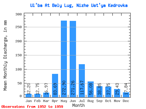
| Statistic | Jan | Feb | Mar | Apr | May | Jun | Jul | Aug | Sep | Oct | Nov | Dec | Annual |
|---|---|---|---|---|---|---|---|---|---|---|---|---|---|
| Mean | 12.20 | 12.86 | 16.97 | 83.69 | 272.86 | 271.26 | 117.65 | 56.07 | 38.85 | 37.74 | 29.43 | 17.83 | 1225.89 |
| Standard Deviation | 2.57 | 3.98 | 2.46 | 22.90 | 76.64 | 125.81 | 86.10 | 34.61 | 17.48 | 14.99 | 13.01 | 4.14 | 113.56 |
| Min | 9.94 | 8.87 | 15.58 | 69.62 | 167.32 | 112.25 | 26.78 | 20.45 | 18.72 | 20.76 | 19.39 | 12.77 | 1145.59 |
| Max | 15.78 | 17.48 | 20.65 | 110.11 | 356.33 | 484.13 | 265.59 | 124.16 | 65.12 | 63.52 | 47.77 | 22.57 | 1306.20 |
| Coefficient of Variation | 0.21 | 0.31 | 0.14 | 0.27 | 0.28 | 0.46 | 0.73 | 0.62 | 0.45 | 0.40 | 0.44 | 0.23 | 0.09 |
 Return to R-Arctic Net Home Page