|
|
|||||||||||||||||
| Point ID: 8579 | Downloads | Plots | Site Data | Code: 11154 |
|
|
|||||||||||||||||
| Download | |
|---|---|
| Site Descriptor Information | Site Time Series Data |
| Link to all available data | |
| View: | Time Series | All |
| Units: | m3/s |
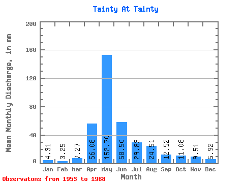
| Statistic | Jan | Feb | Mar | Apr | May | Jun | Jul | Aug | Sep | Oct | Nov | Dec | Annual |
|---|---|---|---|---|---|---|---|---|---|---|---|---|---|
| Mean | 4.30 | 3.28 | 7.26 | 56.08 | 152.68 | 58.50 | 29.83 | 24.50 | 12.52 | 11.09 | 9.51 | 5.92 | 380.28 |
| Standard Deviation | 2.36 | 1.30 | 4.86 | 40.93 | 105.92 | 46.45 | 29.05 | 31.30 | 9.70 | 6.01 | 4.58 | 3.06 | 188.87 |
| Min | 1.06 | 0.94 | 1.63 | 15.61 | 15.68 | 7.16 | 6.36 | 5.33 | 3.44 | 4.29 | 4.30 | 1.63 | 175.09 |
| Max | 8.43 | 5.12 | 20.57 | 130.60 | 399.48 | 167.55 | 118.51 | 109.19 | 36.80 | 25.89 | 20.77 | 13.02 | 826.05 |
| Coefficient of Variation | 0.55 | 0.40 | 0.67 | 0.73 | 0.69 | 0.79 | 0.97 | 1.28 | 0.78 | 0.54 | 0.48 | 0.52 | 0.50 |
 Return to R-Arctic Net Home Page