|
|
|||||||||||||||||
| Point ID: 8575 | Downloads | Plots | Site Data | Code: 11142 |
|
|
|||||||||||||||||
| Download | |
|---|---|
| Site Descriptor Information | Site Time Series Data |
| Link to all available data | |
| View: | Time Series | All |
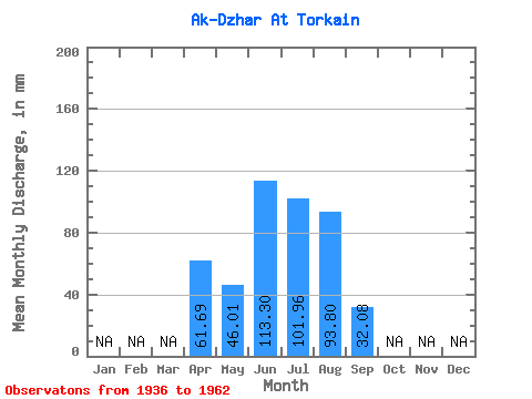
| Units: | m3/s |
| Statistic | Jan | Feb | Mar | Apr | May | Jun | Jul | Aug | Sep | Oct | Nov | Dec | Annual |
|---|---|---|---|---|---|---|---|---|---|---|---|---|---|
| Mean | 61.67 | 46.01 | 113.31 | 101.96 | 93.79 | 32.09 | |||||||
| Standard Deviation | 19.35 | 74.13 | 79.54 | 66.47 | 16.73 | ||||||||
| Min | 61.67 | 29.20 | 34.56 | 23.80 | 16.70 | 13.86 | |||||||
| Max | 61.67 | 73.83 | 229.86 | 217.87 | 183.33 | 62.24 | |||||||
| Coefficient of Variation | 0.42 | 0.65 | 0.78 | 0.71 | 0.52 |
 Return to R-Arctic Net Home Page