|
|
|||||||||||||||||
| Point ID: 8567 | Downloads | Plots | Site Data | Code: 11111 |
|
|
|||||||||||||||||
| Download | |
|---|---|
| Site Descriptor Information | Site Time Series Data |
| Link to all available data | |
| View: | Time Series | All |
| Units: | m3/s |
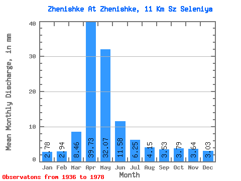
| Statistic | Jan | Feb | Mar | Apr | May | Jun | Jul | Aug | Sep | Oct | Nov | Dec | Annual |
|---|---|---|---|---|---|---|---|---|---|---|---|---|---|
| Mean | 2.78 | 2.97 | 8.46 | 39.72 | 32.07 | 11.58 | 6.25 | 4.15 | 3.53 | 3.79 | 3.64 | 3.03 | 118.13 |
| Standard Deviation | 1.22 | 2.38 | 6.36 | 25.99 | 24.52 | 8.67 | 4.63 | 3.72 | 2.38 | 2.57 | 2.88 | 1.72 | 49.80 |
| Min | 1.19 | 1.08 | 2.89 | 5.82 | 2.45 | 0.17 | 0.00 | 0.39 | 0.64 | 1.48 | 1.08 | 0.89 | 57.04 |
| Max | 4.97 | 9.40 | 22.63 | 141.45 | 117.95 | 46.89 | 24.27 | 19.29 | 12.07 | 12.46 | 12.21 | 5.64 | 181.19 |
| Coefficient of Variation | 0.44 | 0.80 | 0.75 | 0.65 | 0.77 | 0.75 | 0.74 | 0.90 | 0.67 | 0.68 | 0.79 | 0.57 | 0.42 |
 Return to R-Arctic Net Home Page