|
|
|||||||||||||||||
| Point ID: 8557 | Downloads | Plots | Site Data | Code: 11095 |
|
|
|||||||||||||||||
| Download | |
|---|---|
| Site Descriptor Information | Site Time Series Data |
| Link to all available data | |
| View: | Time Series | All |
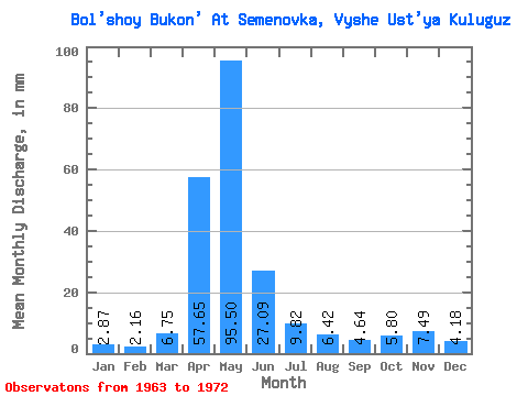
| Units: | m3/s |
| Statistic | Jan | Feb | Mar | Apr | May | Jun | Jul | Aug | Sep | Oct | Nov | Dec | Annual |
|---|---|---|---|---|---|---|---|---|---|---|---|---|---|
| Mean | 2.87 | 2.18 | 6.75 | 57.65 | 95.49 | 27.09 | 9.82 | 6.42 | 4.63 | 5.79 | 7.49 | 4.18 | 222.03 |
| Standard Deviation | 1.37 | 0.57 | 5.53 | 34.59 | 75.24 | 25.66 | 6.46 | 4.99 | 2.00 | 1.99 | 4.76 | 2.00 | 136.46 |
| Min | 0.84 | 1.53 | 2.34 | 13.39 | 24.42 | 7.39 | 3.18 | 1.94 | 2.29 | 3.68 | 2.69 | 1.89 | 81.79 |
| Max | 5.04 | 3.21 | 18.14 | 125.28 | 232.36 | 86.91 | 22.08 | 17.75 | 8.41 | 9.14 | 18.75 | 7.46 | 457.77 |
| Coefficient of Variation | 0.48 | 0.26 | 0.82 | 0.60 | 0.79 | 0.95 | 0.66 | 0.78 | 0.43 | 0.34 | 0.64 | 0.48 | 0.61 |
 Return to R-Arctic Net Home Page