|
|
|||||||||||||||||
| Point ID: 8553 | Downloads | Plots | Site Data | Code: 11083 |
|
|
|||||||||||||||||
| Download | |
|---|---|
| Site Descriptor Information | Site Time Series Data |
| Link to all available data | |
| View: | Time Series | All |
| Units: | m3/s |
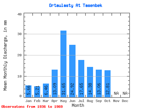
| Statistic | Jan | Feb | Mar | Apr | May | Jun | Jul | Aug | Sep | Oct | Nov | Dec | Annual |
|---|---|---|---|---|---|---|---|---|---|---|---|---|---|
| Mean | 5.66 | 5.25 | 6.45 | 13.10 | 31.65 | 24.92 | 17.65 | 14.39 | 13.06 | 12.80 | |||
| Standard Deviation | 6.38 | 16.88 | 15.42 | 11.76 | 12.47 | 5.13 | |||||||
| Min | 5.66 | 5.25 | 6.45 | 5.48 | 13.10 | 6.53 | 3.67 | 2.98 | 8.45 | 12.80 | |||
| Max | 5.66 | 5.25 | 6.45 | 22.85 | 78.96 | 73.54 | 51.19 | 50.09 | 22.08 | 12.80 | |||
| Coefficient of Variation | 0.49 | 0.53 | 0.62 | 0.67 | 0.87 | 0.39 |
 Return to R-Arctic Net Home Page