|
|
|||||||||||||||||
| Point ID: 8536 | Downloads | Plots | Site Data | Code: 10694 |
|
|
|||||||||||||||||
| Download | |
|---|---|
| Site Descriptor Information | Site Time Series Data |
| Link to all available data | |
| View: | Time Series | All |
| Units: | m3/s |
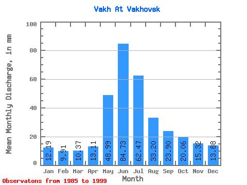
| Statistic | Jan | Feb | Mar | Apr | May | Jun | Jul | Aug | Sep | Oct | Nov | Dec | Annual |
|---|---|---|---|---|---|---|---|---|---|---|---|---|---|
| Mean | 12.19 | 9.99 | 10.37 | 13.11 | 48.98 | 84.73 | 62.46 | 33.19 | 23.90 | 20.06 | 15.32 | 13.88 | 347.37 |
| Standard Deviation | 2.35 | 1.93 | 1.56 | 5.36 | 26.49 | 12.38 | 22.76 | 13.58 | 9.19 | 4.20 | 4.00 | 2.90 | 58.60 |
| Min | 7.96 | 6.25 | 7.81 | 8.81 | 21.20 | 71.03 | 41.79 | 17.15 | 14.57 | 14.15 | 8.99 | 9.29 | 237.73 |
| Max | 14.44 | 11.64 | 12.01 | 23.20 | 85.77 | 106.08 | 100.54 | 59.09 | 42.48 | 25.54 | 19.65 | 17.54 | 431.00 |
| Coefficient of Variation | 0.19 | 0.19 | 0.15 | 0.41 | 0.54 | 0.15 | 0.36 | 0.41 | 0.38 | 0.21 | 0.26 | 0.21 | 0.17 |
 Return to R-Arctic Net Home Page