|
|
|||||||||||||||||
| Point ID: 8527 | Downloads | Plots | Site Data | Code: 10610 |
|
|
|||||||||||||||||
| Download | |
|---|---|
| Site Descriptor Information | Site Time Series Data |
| Link to all available data | |
| View: | Time Series | All |
| Units: | m3/s |
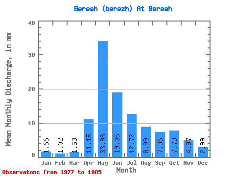
| Statistic | Jan | Feb | Mar | Apr | May | Jun | Jul | Aug | Sep | Oct | Nov | Dec | Annual |
|---|---|---|---|---|---|---|---|---|---|---|---|---|---|
| Mean | 1.66 | 1.02 | 1.52 | 11.15 | 33.98 | 19.05 | 12.72 | 8.98 | 7.35 | 7.79 | 4.97 | 3.00 | 112.66 |
| Standard Deviation | 0.47 | 0.62 | 0.69 | 5.67 | 8.69 | 10.02 | 3.97 | 2.55 | 2.35 | 1.59 | 1.23 | 0.63 | 26.70 |
| Min | 0.93 | 0.25 | 0.52 | 4.47 | 18.42 | 7.57 | 3.88 | 4.70 | 4.87 | 5.71 | 2.91 | 2.06 | 63.81 |
| Max | 2.35 | 2.21 | 2.70 | 20.10 | 44.24 | 41.13 | 17.31 | 13.93 | 11.81 | 9.82 | 6.95 | 4.00 | 162.03 |
| Coefficient of Variation | 0.28 | 0.60 | 0.45 | 0.51 | 0.26 | 0.53 | 0.31 | 0.28 | 0.32 | 0.20 | 0.25 | 0.21 | 0.24 |
 Return to R-Arctic Net Home Page