|
|
|||||||||||||||||
| Point ID: 8510 | Downloads | Plots | Site Data | Code: 10484 |
|
|
|||||||||||||||||
| Download | |
|---|---|
| Site Descriptor Information | Site Time Series Data |
| Link to all available data | |
| View: | Time Series | All |
| Units: | m3/s |
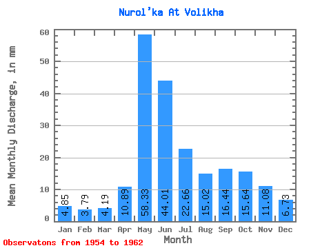
| Statistic | Jan | Feb | Mar | Apr | May | Jun | Jul | Aug | Sep | Oct | Nov | Dec | Annual |
|---|---|---|---|---|---|---|---|---|---|---|---|---|---|
| Mean | 4.85 | 3.83 | 4.19 | 10.89 | 58.32 | 44.01 | 22.66 | 15.02 | 16.44 | 15.63 | 11.08 | 6.73 | 231.14 |
| Standard Deviation | 0.83 | 0.30 | 0.59 | 4.64 | 6.90 | 12.19 | 15.15 | 6.26 | 5.90 | 5.00 | 4.90 | 2.08 | 38.54 |
| Min | 3.74 | 3.46 | 3.47 | 6.98 | 50.91 | 30.02 | 6.84 | 6.02 | 10.40 | 9.03 | 4.51 | 3.64 | 173.71 |
| Max | 6.05 | 4.25 | 5.06 | 18.82 | 66.45 | 59.20 | 43.64 | 23.34 | 27.58 | 23.80 | 17.02 | 8.40 | 256.54 |
| Coefficient of Variation | 0.17 | 0.08 | 0.14 | 0.43 | 0.12 | 0.28 | 0.67 | 0.42 | 0.36 | 0.32 | 0.44 | 0.31 | 0.17 |
 Return to R-Arctic Net Home Page