|
|
|||||||||||||||||
| Point ID: 8476 | Downloads | Plots | Site Data | Code: 10311 |
|
|
|||||||||||||||||
| Download | |
|---|---|
| Site Descriptor Information | Site Time Series Data |
| Link to all available data | |
| View: | Time Series | All |
| Units: | m3/s |
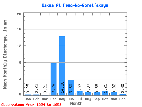
| Statistic | Jan | Feb | Mar | Apr | May | Jun | Jul | Aug | Sep | Oct | Nov | Dec | Annual |
|---|---|---|---|---|---|---|---|---|---|---|---|---|---|
| Mean | 0.25 | 0.23 | 0.21 | 7.75 | 14.30 | 3.80 | 1.02 | 0.87 | 0.88 | 1.21 | 0.82 | 0.30 | 29.18 |
| Standard Deviation | 0.04 | 0.03 | 0.04 | 5.64 | 6.82 | 3.37 | 0.55 | 0.37 | 0.42 | 1.05 | 0.42 | 0.07 | 14.12 |
| Min | 0.21 | 0.17 | 0.17 | 1.14 | 5.08 | 0.98 | 0.53 | 0.42 | 0.44 | 0.56 | 0.32 | 0.22 | 17.76 |
| Max | 0.32 | 0.26 | 0.25 | 15.54 | 22.19 | 8.94 | 1.67 | 1.25 | 1.41 | 2.78 | 1.35 | 0.37 | 48.42 |
| Coefficient of Variation | 0.17 | 0.15 | 0.18 | 0.73 | 0.48 | 0.89 | 0.54 | 0.42 | 0.48 | 0.87 | 0.52 | 0.24 | 0.48 |
 Return to R-Arctic Net Home Page