|
|
|||||||||||||||||
| Point ID: 8474 | Downloads | Plots | Site Data | Code: 10307 |
|
|
|||||||||||||||||
| Download | |
|---|---|
| Site Descriptor Information | Site Time Series Data |
| Link to all available data | |
| View: | Time Series | All |
| Units: | m3/s |
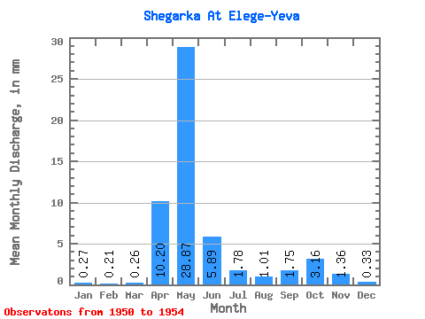
| Statistic | Jan | Feb | Mar | Apr | May | Jun | Jul | Aug | Sep | Oct | Nov | Dec | Annual |
|---|---|---|---|---|---|---|---|---|---|---|---|---|---|
| Mean | 0.27 | 0.21 | 0.26 | 10.20 | 28.87 | 5.89 | 1.78 | 1.01 | 1.75 | 3.16 | 1.36 | 0.33 | 61.26 |
| Standard Deviation | 0.09 | 0.06 | 0.06 | 10.95 | 23.97 | 5.67 | 1.33 | 0.79 | 1.65 | 3.52 | 1.35 | 0.19 | 38.92 |
| Min | 0.18 | 0.14 | 0.18 | 0.47 | 11.38 | 0.91 | 0.45 | 0.21 | 0.21 | 0.39 | 0.34 | 0.20 | 24.71 |
| Max | 0.38 | 0.30 | 0.32 | 27.64 | 70.54 | 15.62 | 3.27 | 2.07 | 3.76 | 7.80 | 3.24 | 0.62 | 108.92 |
| Coefficient of Variation | 0.35 | 0.28 | 0.22 | 1.07 | 0.83 | 0.96 | 0.75 | 0.78 | 0.95 | 1.11 | 0.99 | 0.58 | 0.64 |
 Return to R-Arctic Net Home Page