|
|
|||||||||||||||||
| Point ID: 8464 | Downloads | Plots | Site Data | Code: 10245 |
|
|
|||||||||||||||||
| Download | |
|---|---|
| Site Descriptor Information | Site Time Series Data |
| Link to all available data | |
| View: | Time Series | All |
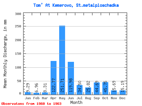
| Units: | m3/s |
| Statistic | Jan | Feb | Mar | Apr | May | Jun | Jul | Aug | Sep | Oct | Nov | Dec | Annual |
|---|---|---|---|---|---|---|---|---|---|---|---|---|---|
| Mean | 9.29 | 7.02 | 8.31 | 122.77 | 251.67 | 119.98 | 34.50 | 25.82 | 44.69 | 45.75 | 15.69 | 15.19 | 739.94 |
| Standard Deviation | 1.06 | 0.52 | 0.54 | 79.04 | 19.64 | 49.68 | 17.77 | 11.83 | 21.98 | 12.78 | 8.64 | 3.69 | 80.97 |
| Min | 8.18 | 6.61 | 7.54 | 54.07 | 228.64 | 81.38 | 19.93 | 13.82 | 11.87 | 31.16 | 4.46 | 10.94 | 648.79 |
| Max | 10.65 | 7.77 | 8.75 | 215.72 | 274.71 | 191.75 | 59.32 | 40.49 | 58.53 | 54.94 | 24.25 | 19.75 | 803.54 |
| Coefficient of Variation | 0.11 | 0.07 | 0.06 | 0.64 | 0.08 | 0.41 | 0.52 | 0.46 | 0.49 | 0.28 | 0.55 | 0.24 | 0.11 |
 Return to R-Arctic Net Home Page