|
|
|||||||||||||||||
| Point ID: 8449 | Downloads | Plots | Site Data | Code: 10185 |
|
|
|||||||||||||||||
| Download | |
|---|---|
| Site Descriptor Information | Site Time Series Data |
| Link to all available data | |
| View: | Time Series | All |
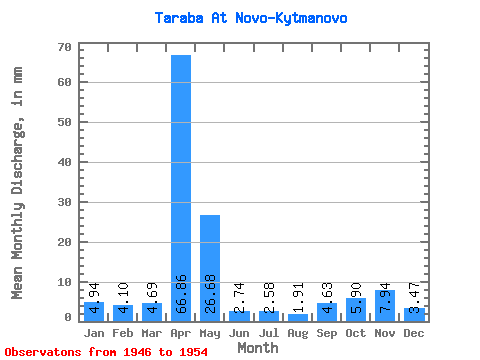
| Units: | m3/s |
| Statistic | Jan | Feb | Mar | Apr | May | Jun | Jul | Aug | Sep | Oct | Nov | Dec | Annual |
|---|---|---|---|---|---|---|---|---|---|---|---|---|---|
| Mean | 4.93 | 4.13 | 4.68 | 66.86 | 26.69 | 2.73 | 2.57 | 1.91 | 4.63 | 5.89 | 7.94 | 3.47 | 140.67 |
| Standard Deviation | 1.87 | 1.04 | 1.82 | 24.82 | 24.88 | 2.73 | 1.77 | 1.25 | 4.00 | 3.55 | 8.31 | 2.16 | 21.59 |
| Min | 2.99 | 2.71 | 2.73 | 24.96 | 9.18 | 0.72 | 0.50 | 0.35 | 0.53 | 0.00 | 1.34 | 1.41 | 110.53 |
| Max | 7.44 | 5.20 | 7.44 | 95.04 | 84.31 | 9.36 | 6.20 | 4.21 | 13.20 | 12.15 | 25.68 | 8.43 | 173.04 |
| Coefficient of Variation | 0.38 | 0.25 | 0.39 | 0.37 | 0.93 | 1.00 | 0.69 | 0.65 | 0.86 | 0.60 | 1.05 | 0.62 | 0.15 |
 Return to R-Arctic Net Home Page