|
|
|||||||||||||||||
| Point ID: 8446 | Downloads | Plots | Site Data | Code: 10178 |
|
|
|||||||||||||||||
| Download | |
|---|---|
| Site Descriptor Information | Site Time Series Data |
| Link to all available data | |
| View: | Time Series | All |
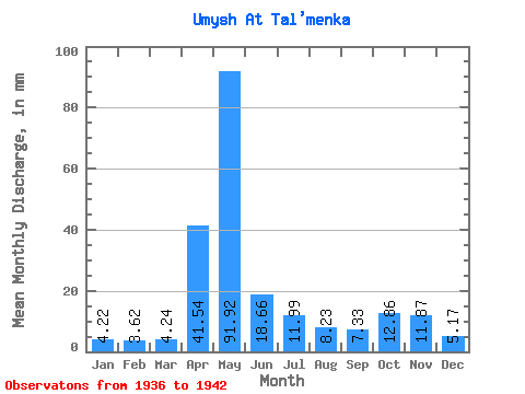
| Units: | m3/s |
| Statistic | Jan | Feb | Mar | Apr | May | Jun | Jul | Aug | Sep | Oct | Nov | Dec | Annual |
|---|---|---|---|---|---|---|---|---|---|---|---|---|---|
| Mean | 4.21 | 3.65 | 4.24 | 41.54 | 91.90 | 18.66 | 11.99 | 8.23 | 7.33 | 12.86 | 11.87 | 5.17 | 223.54 |
| Standard Deviation | 1.42 | 1.22 | 1.43 | 31.26 | 46.46 | 8.06 | 6.19 | 4.66 | 4.42 | 7.88 | 5.99 | 1.64 | 48.62 |
| Min | 2.21 | 2.04 | 2.41 | 8.35 | 38.05 | 7.46 | 3.96 | 3.79 | 4.11 | 6.56 | 5.62 | 3.28 | 151.99 |
| Max | 6.56 | 5.75 | 6.33 | 87.26 | 167.71 | 30.85 | 24.60 | 17.93 | 15.13 | 27.02 | 20.52 | 7.92 | 288.48 |
| Coefficient of Variation | 0.34 | 0.34 | 0.34 | 0.75 | 0.51 | 0.43 | 0.52 | 0.57 | 0.60 | 0.61 | 0.50 | 0.32 | 0.22 |
 Return to R-Arctic Net Home Page