|
|
|||||||||||||||||
| Point ID: 8443 | Downloads | Plots | Site Data | Code: 10158 |
|
|
|||||||||||||||||
| Download | |
|---|---|
| Site Descriptor Information | Site Time Series Data |
| Link to all available data | |
| View: | Time Series | All |
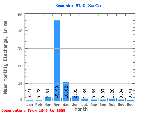
| Units: | m3/s |
| Statistic | Jan | Feb | Mar | Apr | May | Jun | Jul | Aug | Sep | Oct | Nov | Dec | Annual |
|---|---|---|---|---|---|---|---|---|---|---|---|---|---|
| Mean | 0.22 | 0.22 | 2.31 | 45.99 | 10.63 | 2.92 | 1.34 | 0.83 | 0.87 | 1.28 | 0.84 | 0.40 | 70.28 |
| Standard Deviation | 0.23 | 0.28 | 3.45 | 35.54 | 6.08 | 2.95 | 1.22 | 0.76 | 0.92 | 1.23 | 0.54 | 0.37 | 41.98 |
| Min | 0.00 | 0.00 | 0.08 | 12.96 | 2.28 | 0.22 | 0.06 | 0.05 | 0.03 | 0.21 | 0.28 | 0.00 | 22.30 |
| Max | 0.62 | 0.76 | 11.26 | 140.65 | 20.24 | 9.13 | 3.50 | 2.44 | 2.94 | 4.41 | 1.77 | 1.37 | 173.77 |
| Coefficient of Variation | 1.04 | 1.28 | 1.50 | 0.77 | 0.57 | 1.01 | 0.91 | 0.91 | 1.05 | 0.96 | 0.64 | 0.92 | 0.60 |
 Return to R-Arctic Net Home Page