|
|
|||||||||||||||||
| Point ID: 8440 | Downloads | Plots | Site Data | Code: 10149 |
|
|
|||||||||||||||||
| Download | |
|---|---|
| Site Descriptor Information | Site Time Series Data |
| Link to all available data | |
| View: | Time Series | All |
| Units: | m3/s |
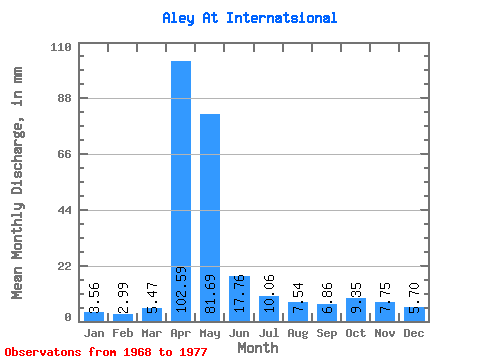
| Statistic | Jan | Feb | Mar | Apr | May | Jun | Jul | Aug | Sep | Oct | Nov | Dec | Annual |
|---|---|---|---|---|---|---|---|---|---|---|---|---|---|
| Mean | 3.56 | 3.02 | 5.47 | 102.59 | 81.68 | 17.76 | 10.06 | 7.54 | 6.86 | 9.35 | 7.75 | 5.70 | 264.83 |
| Standard Deviation | 1.31 | 1.16 | 4.88 | 35.68 | 33.55 | 7.21 | 4.11 | 2.40 | 1.63 | 4.59 | 3.85 | 3.35 | 56.16 |
| Min | 2.05 | 1.46 | 2.39 | 53.53 | 33.41 | 8.26 | 5.32 | 4.00 | 4.31 | 5.43 | 3.87 | 2.15 | 191.68 |
| Max | 5.88 | 4.79 | 17.97 | 164.64 | 136.08 | 28.11 | 18.49 | 10.90 | 9.37 | 20.41 | 16.63 | 13.52 | 350.98 |
| Coefficient of Variation | 0.37 | 0.38 | 0.89 | 0.35 | 0.41 | 0.41 | 0.41 | 0.32 | 0.24 | 0.49 | 0.50 | 0.59 | 0.21 |
 Return to R-Arctic Net Home Page