|
|
|||||||||||||||||
| Point ID: 8407 | Downloads | Plots | Site Data | Code: 9545 |
|
|
|||||||||||||||||
| Download | |
|---|---|
| Site Descriptor Information | Site Time Series Data |
| Link to all available data | |
| View: | Time Series | All |
| Units: | m3/s |
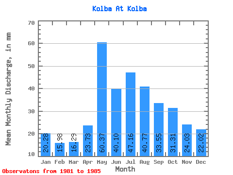
| Statistic | Jan | Feb | Mar | Apr | May | Jun | Jul | Aug | Sep | Oct | Nov | Dec | Annual |
|---|---|---|---|---|---|---|---|---|---|---|---|---|---|
| Mean | 20.27 | 16.12 | 16.28 | 23.73 | 60.36 | 40.10 | 47.15 | 40.76 | 33.55 | 31.31 | 24.03 | 22.02 | 371.83 |
| Standard Deviation | 10.96 | 10.23 | 9.52 | 8.88 | 4.88 | 10.40 | 7.01 | 13.57 | 4.33 | 4.52 | 3.89 | 8.20 | 36.86 |
| Min | 11.40 | 7.25 | 7.15 | 17.91 | 55.39 | 28.99 | 42.91 | 30.54 | 30.19 | 24.84 | 20.14 | 13.87 | 332.66 |
| Max | 34.20 | 29.89 | 28.61 | 36.95 | 65.07 | 51.94 | 57.54 | 60.77 | 39.82 | 35.33 | 29.98 | 33.39 | 420.06 |
| Coefficient of Variation | 0.54 | 0.64 | 0.58 | 0.37 | 0.08 | 0.26 | 0.15 | 0.33 | 0.13 | 0.14 | 0.16 | 0.37 | 0.10 |
 Return to R-Arctic Net Home Page