|
|
|||||||||||||||||
| Point ID: 8397 | Downloads | Plots | Site Data | Code: 9510 |
|
|
|||||||||||||||||
| Download | |
|---|---|
| Site Descriptor Information | Site Time Series Data |
| Link to all available data | |
| View: | Time Series | All |
| Units: | m3/s |
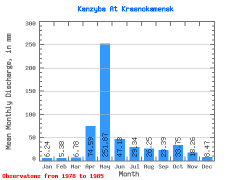
| Statistic | Jan | Feb | Mar | Apr | May | Jun | Jul | Aug | Sep | Oct | Nov | Dec | Annual |
|---|---|---|---|---|---|---|---|---|---|---|---|---|---|
| Mean | 6.23 | 5.42 | 6.77 | 74.59 | 251.84 | 47.13 | 29.33 | 26.24 | 23.38 | 33.73 | 18.27 | 8.47 | 527.73 |
| Standard Deviation | 1.39 | 1.66 | 3.13 | 52.43 | 84.78 | 25.73 | 20.12 | 22.60 | 15.85 | 15.62 | 9.03 | 2.34 | 86.98 |
| Min | 3.71 | 3.00 | 3.30 | 15.95 | 113.71 | 15.55 | 10.92 | 11.74 | 5.78 | 5.78 | 5.00 | 4.33 | 400.77 |
| Max | 8.24 | 7.32 | 12.36 | 164.69 | 372.86 | 88.93 | 59.74 | 78.69 | 53.83 | 49.44 | 34.51 | 10.93 | 630.59 |
| Coefficient of Variation | 0.22 | 0.31 | 0.46 | 0.70 | 0.34 | 0.55 | 0.69 | 0.86 | 0.68 | 0.46 | 0.49 | 0.28 | 0.17 |
 Return to R-Arctic Net Home Page