|
|
|||||||||||||||||
| Point ID: 8395 | Downloads | Plots | Site Data | Code: 9492 |
|
|
|||||||||||||||||
| Download | |
|---|---|
| Site Descriptor Information | Site Time Series Data |
| Link to all available data | |
| View: | Time Series | All |
| Units: | m3/s |
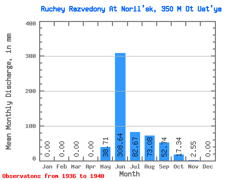
| Statistic | Jan | Feb | Mar | Apr | May | Jun | Jul | Aug | Sep | Oct | Nov | Dec | Annual |
|---|---|---|---|---|---|---|---|---|---|---|---|---|---|
| Mean | 0.00 | 0.00 | 0.00 | 0.00 | 38.70 | 308.64 | 82.66 | 73.06 | 52.74 | 17.40 | 2.55 | 0.00 | 590.12 |
| Standard Deviation | 0.00 | 0.00 | 0.00 | 0.00 | 65.26 | 50.25 | 34.90 | 37.05 | 29.31 | 7.53 | 3.33 | 0.00 | 145.77 |
| Min | 0.00 | 0.00 | 0.00 | 0.00 | 0.00 | 271.19 | 52.63 | 30.96 | 25.47 | 8.36 | 0.00 | 0.00 | 405.45 |
| Max | 0.00 | 0.00 | 0.00 | 0.00 | 136.22 | 380.56 | 133.13 | 131.58 | 97.39 | 27.86 | 7.49 | 0.00 | 761.64 |
| Coefficient of Variation | 1.69 | 0.16 | 0.42 | 0.51 | 0.56 | 0.43 | 1.31 | 0.25 |
 Return to R-Arctic Net Home Page