|
|
|||||||||||||||||
| Point ID: 8387 | Downloads | Plots | Site Data | Code: 9475 |
|
|
|||||||||||||||||
| Download | |
|---|---|
| Site Descriptor Information | Site Time Series Data |
| Link to all available data | |
| View: | Time Series | All |
| Units: | m3/s |
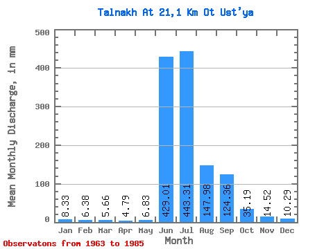
| Statistic | Jan | Feb | Mar | Apr | May | Jun | Jul | Aug | Sep | Oct | Nov | Dec | Annual |
|---|---|---|---|---|---|---|---|---|---|---|---|---|---|
| Mean | 8.36 | 6.43 | 5.69 | 4.79 | 6.80 | 428.98 | 443.23 | 147.97 | 124.36 | 35.22 | 14.50 | 10.27 | 1218.98 |
| Standard Deviation | 4.07 | 2.60 | 2.69 | 2.03 | 4.66 | 230.64 | 209.86 | 80.56 | 69.00 | 24.73 | 3.81 | 3.90 | 254.25 |
| Min | 0.63 | 3.79 | 1.02 | 1.82 | 2.91 | 158.87 | 137.43 | 65.97 | 21.13 | 19.63 | 9.88 | 5.11 | 947.88 |
| Max | 15.71 | 12.16 | 10.99 | 9.12 | 17.28 | 972.95 | 793.19 | 379.32 | 278.96 | 115.44 | 22.04 | 18.85 | 1713.51 |
| Coefficient of Variation | 0.49 | 0.40 | 0.47 | 0.42 | 0.68 | 0.54 | 0.47 | 0.54 | 0.56 | 0.70 | 0.26 | 0.38 | 0.21 |
 Return to R-Arctic Net Home Page