|
|
|||||||||||||||||
| Point ID: 8379 | Downloads | Plots | Site Data | Code: 9461 |
|
|
|||||||||||||||||
| Download | |
|---|---|
| Site Descriptor Information | Site Time Series Data |
| Link to all available data | |
| View: | Time Series | All |
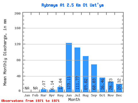
| Units: | m3/s |
| Statistic | Jan | Feb | Mar | Apr | May | Jun | Jul | Aug | Sep | Oct | Nov | Dec | Annual |
|---|---|---|---|---|---|---|---|---|---|---|---|---|---|
| Mean | 7.07 | 6.14 | 12.84 | 123.11 | 111.75 | 89.81 | 68.83 | 36.45 | 26.23 | 20.32 | |||
| Standard Deviation | |||||||||||||
| Min | 7.07 | 6.14 | 12.84 | 123.11 | 111.75 | 89.81 | 68.83 | 36.45 | 26.23 | 20.32 | |||
| Max | 7.07 | 6.14 | 12.84 | 123.11 | 111.75 | 89.81 | 68.83 | 36.45 | 26.23 | 20.32 | |||
| Coefficient of Variation |
 Return to R-Arctic Net Home Page