|
|
|||||||||||||||||
| Point ID: 8370 | Downloads | Plots | Site Data | Code: 9402 |
|
|
|||||||||||||||||
| Download | |
|---|---|
| Site Descriptor Information | Site Time Series Data |
| Link to all available data | |
| View: | Time Series | All |
| Units: | m3/s |
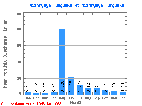
| Statistic | Jan | Feb | Mar | Apr | May | Jun | Jul | Aug | Sep | Oct | Nov | Dec | Annual |
|---|---|---|---|---|---|---|---|---|---|---|---|---|---|
| Mean | 2.81 | 2.34 | 2.37 | 3.81 | 80.27 | 21.25 | 11.77 | 8.12 | 7.74 | 6.44 | 4.08 | 3.43 | 153.18 |
| Standard Deviation | 1.06 | 0.94 | 0.98 | 2.93 | 23.14 | 7.28 | 8.12 | 3.57 | 3.50 | 2.87 | 1.56 | 1.24 | 26.50 |
| Min | 1.17 | 1.03 | 1.24 | 1.52 | 24.50 | 8.67 | 5.44 | 3.90 | 3.84 | 3.12 | 2.29 | 1.90 | 106.88 |
| Max | 4.60 | 3.94 | 4.44 | 12.96 | 110.22 | 33.50 | 36.98 | 16.21 | 16.22 | 12.39 | 8.16 | 6.39 | 202.53 |
| Coefficient of Variation | 0.38 | 0.40 | 0.41 | 0.77 | 0.29 | 0.34 | 0.69 | 0.44 | 0.45 | 0.45 | 0.38 | 0.36 | 0.17 |
 Return to R-Arctic Net Home Page