|
|
|||||||||||||||||
| Point ID: 8367 | Downloads | Plots | Site Data | Code: 9395 |
|
|
|||||||||||||||||
| Download | |
|---|---|
| Site Descriptor Information | Site Time Series Data |
| Link to all available data | |
| View: | Time Series | All |
| Units: | m3/s |
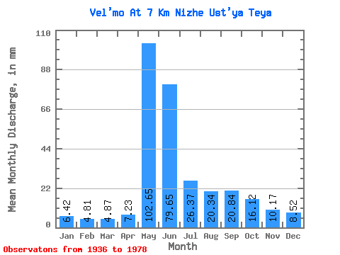
| Statistic | Jan | Feb | Mar | Apr | May | Jun | Jul | Aug | Sep | Oct | Nov | Dec | Annual |
|---|---|---|---|---|---|---|---|---|---|---|---|---|---|
| Mean | 6.42 | 4.86 | 4.87 | 7.23 | 102.64 | 79.65 | 26.37 | 20.34 | 20.84 | 16.12 | 10.17 | 8.52 | 309.96 |
| Standard Deviation | 1.95 | 1.49 | 1.42 | 5.60 | 23.74 | 33.00 | 9.55 | 10.04 | 9.79 | 7.07 | 3.30 | 2.73 | 59.60 |
| Min | 2.15 | 1.32 | 1.29 | 2.92 | 51.57 | 36.56 | 9.72 | 9.79 | 9.65 | 6.88 | 3.48 | 3.88 | 226.81 |
| Max | 10.56 | 7.88 | 7.87 | 33.28 | 159.04 | 202.61 | 52.62 | 47.24 | 45.27 | 39.29 | 20.94 | 16.02 | 467.83 |
| Coefficient of Variation | 0.30 | 0.31 | 0.29 | 0.78 | 0.23 | 0.41 | 0.36 | 0.49 | 0.47 | 0.44 | 0.33 | 0.32 | 0.19 |
 Return to R-Arctic Net Home Page