|
|
|||||||||||||||||
| Point ID: 8364 | Downloads | Plots | Site Data | Code: 9377 |
|
|
|||||||||||||||||
| Download | |
|---|---|
| Site Descriptor Information | Site Time Series Data |
| Link to all available data | |
| View: | Time Series | All |
| Units: | m3/s |
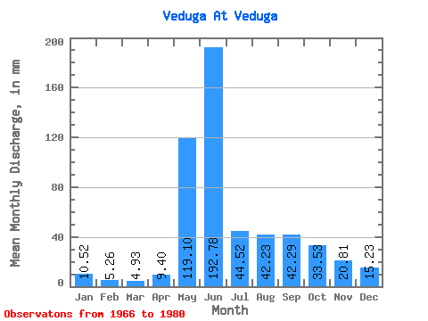
| Statistic | Jan | Feb | Mar | Apr | May | Jun | Jul | Aug | Sep | Oct | Nov | Dec | Annual |
|---|---|---|---|---|---|---|---|---|---|---|---|---|---|
| Mean | 10.52 | 5.30 | 4.93 | 9.40 | 119.08 | 192.78 | 44.51 | 42.22 | 42.29 | 33.53 | 20.81 | 15.23 | 542.70 |
| Standard Deviation | 5.63 | 1.83 | 0.90 | 7.38 | 29.12 | 65.38 | 10.96 | 16.96 | 19.23 | 16.54 | 14.51 | 9.81 | 96.44 |
| Min | 2.97 | 0.74 | 3.78 | 4.01 | 81.92 | 76.67 | 30.16 | 20.43 | 16.03 | 8.10 | 8.76 | 6.80 | 395.38 |
| Max | 26.55 | 8.61 | 6.71 | 31.15 | 180.03 | 324.11 | 67.51 | 69.31 | 84.51 | 58.51 | 60.99 | 43.43 | 697.37 |
| Coefficient of Variation | 0.54 | 0.34 | 0.18 | 0.79 | 0.24 | 0.34 | 0.25 | 0.40 | 0.46 | 0.49 | 0.70 | 0.64 | 0.18 |
 Return to R-Arctic Net Home Page