|
|
|||||||||||||||||
| Point ID: 8361 | Downloads | Plots | Site Data | Code: 9364 |
|
|
|||||||||||||||||
| Download | |
|---|---|
| Site Descriptor Information | Site Time Series Data |
| Link to all available data | |
| View: | Time Series | All |
| Units: | m3/s |
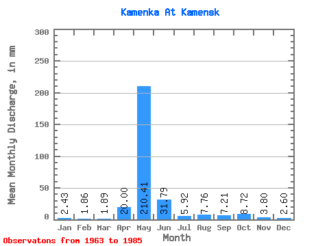
| Statistic | Jan | Feb | Mar | Apr | May | Jun | Jul | Aug | Sep | Oct | Nov | Dec | Annual |
|---|---|---|---|---|---|---|---|---|---|---|---|---|---|
| Mean | 2.42 | 1.89 | 1.90 | 20.00 | 210.39 | 31.79 | 5.92 | 7.77 | 7.20 | 8.71 | 3.81 | 2.62 | 301.20 |
| Standard Deviation | 1.43 | 1.19 | 1.02 | 29.65 | 75.61 | 28.24 | 3.25 | 5.91 | 3.54 | 4.87 | 1.72 | 1.22 | 87.14 |
| Min | 0.00 | 0.00 | 0.00 | 0.05 | 39.80 | 8.56 | 1.82 | 1.40 | 2.21 | 2.09 | 0.55 | 0.00 | 115.04 |
| Max | 6.63 | 4.92 | 3.44 | 93.69 | 329.22 | 131.50 | 15.97 | 24.57 | 15.46 | 21.38 | 6.42 | 4.67 | 427.89 |
| Coefficient of Variation | 0.59 | 0.63 | 0.54 | 1.48 | 0.36 | 0.89 | 0.55 | 0.76 | 0.49 | 0.56 | 0.45 | 0.47 | 0.29 |
 Return to R-Arctic Net Home Page