|
|
|||||||||||||||||
| Point ID: 8352 | Downloads | Plots | Site Data | Code: 9321 |
|
|
|||||||||||||||||
| Download | |
|---|---|
| Site Descriptor Information | Site Time Series Data |
| Link to all available data | |
| View: | Time Series | All |
| Units: | m3/s |
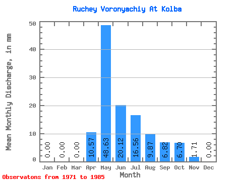
| Statistic | Jan | Feb | Mar | Apr | May | Jun | Jul | Aug | Sep | Oct | Nov | Dec | Annual |
|---|---|---|---|---|---|---|---|---|---|---|---|---|---|
| Mean | 0.00 | 0.00 | 0.00 | 10.65 | 48.45 | 20.07 | 16.54 | 9.79 | 6.92 | 6.70 | 1.57 | 0.07 | 119.98 |
| Standard Deviation | 0.00 | 0.00 | 0.00 | 10.96 | 20.20 | 15.96 | 13.99 | 11.85 | 8.39 | 4.44 | 1.97 | 0.20 | 50.16 |
| Min | 0.00 | 0.00 | 0.00 | 0.00 | 7.75 | 2.73 | 0.35 | 0.00 | 0.00 | 0.00 | 0.00 | 0.00 | 21.11 |
| Max | 0.00 | 0.00 | 0.00 | 32.06 | 81.05 | 64.80 | 49.33 | 38.76 | 31.72 | 15.50 | 5.80 | 0.70 | 206.59 |
| Coefficient of Variation | 1.03 | 0.42 | 0.80 | 0.85 | 1.21 | 1.21 | 0.66 | 1.26 | 2.80 | 0.42 |
 Return to R-Arctic Net Home Page