|
|
|||||||||||||||||
| Point ID: 8340 | Downloads | Plots | Site Data | Code: 9302 |
|
|
|||||||||||||||||
| Download | |
|---|---|
| Site Descriptor Information | Site Time Series Data |
| Link to all available data | |
| View: | Time Series | All |
| Units: | m3/s |
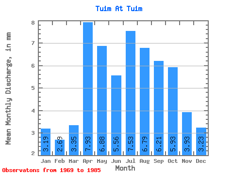
| Statistic | Jan | Feb | Mar | Apr | May | Jun | Jul | Aug | Sep | Oct | Nov | Dec | Annual |
|---|---|---|---|---|---|---|---|---|---|---|---|---|---|
| Mean | 3.20 | 2.72 | 3.35 | 7.92 | 6.89 | 5.57 | 7.52 | 6.79 | 6.21 | 5.92 | 3.94 | 3.23 | 63.26 |
| Standard Deviation | 2.35 | 2.06 | 2.70 | 5.23 | 3.85 | 3.23 | 7.75 | 5.14 | 4.72 | 4.48 | 2.70 | 2.61 | 38.35 |
| Min | 0.74 | 0.08 | 0.00 | 2.08 | 2.24 | 2.46 | 3.00 | 3.23 | 2.91 | 2.26 | 1.21 | 0.97 | 32.88 |
| Max | 9.70 | 8.20 | 10.85 | 22.79 | 16.62 | 12.29 | 32.32 | 22.86 | 21.67 | 20.78 | 12.07 | 11.31 | 153.27 |
| Coefficient of Variation | 0.74 | 0.76 | 0.81 | 0.66 | 0.56 | 0.58 | 1.03 | 0.76 | 0.76 | 0.76 | 0.69 | 0.81 | 0.61 |
 Return to R-Arctic Net Home Page