|
|
|||||||||||||||||
| Point ID: 8333 | Downloads | Plots | Site Data | Code: 9289 |
|
|
|||||||||||||||||
| Download | |
|---|---|
| Site Descriptor Information | Site Time Series Data |
| Link to all available data | |
| View: | Time Series | All |
| Units: | m3/s |
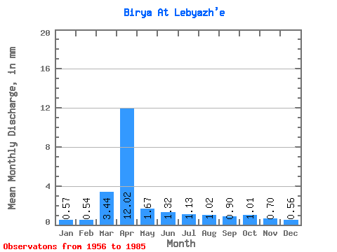
| Statistic | Jan | Feb | Mar | Apr | May | Jun | Jul | Aug | Sep | Oct | Nov | Dec | Annual |
|---|---|---|---|---|---|---|---|---|---|---|---|---|---|
| Mean | 0.57 | 0.54 | 3.44 | 12.03 | 1.67 | 1.31 | 1.12 | 1.03 | 0.91 | 1.01 | 0.69 | 0.57 | 25.04 |
| Standard Deviation | 0.13 | 0.17 | 4.02 | 12.32 | 1.19 | 0.96 | 0.61 | 0.59 | 0.31 | 0.35 | 0.21 | 0.14 | 14.55 |
| Min | 0.28 | 0.26 | 0.34 | 1.09 | 0.80 | 0.37 | 0.61 | 0.49 | 0.40 | 0.55 | 0.45 | 0.25 | 11.56 |
| Max | 0.90 | 1.13 | 15.98 | 51.73 | 7.20 | 5.66 | 3.49 | 3.38 | 1.63 | 2.02 | 1.52 | 0.85 | 79.52 |
| Coefficient of Variation | 0.23 | 0.31 | 1.17 | 1.02 | 0.71 | 0.73 | 0.54 | 0.58 | 0.34 | 0.34 | 0.31 | 0.24 | 0.58 |
 Return to R-Arctic Net Home Page