|
|
|||||||||||||||||
| Point ID: 8330 | Downloads | Plots | Site Data | Code: 9278 |
|
|
|||||||||||||||||
| Download | |
|---|---|
| Site Descriptor Information | Site Time Series Data |
| Link to all available data | |
| View: | Time Series | All |
| Units: | m3/s |
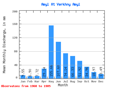
| Statistic | Jan | Feb | Mar | Apr | May | Jun | Jul | Aug | Sep | Oct | Nov | Dec | Annual |
|---|---|---|---|---|---|---|---|---|---|---|---|---|---|
| Mean | 9.54 | 6.96 | 7.71 | 29.14 | 155.63 | 107.60 | 74.13 | 66.32 | 51.92 | 34.96 | 18.97 | 13.49 | 573.49 |
| Standard Deviation | 1.65 | 1.61 | 2.38 | 18.29 | 45.97 | 58.36 | 30.10 | 22.27 | 17.23 | 8.68 | 5.50 | 3.30 | 122.34 |
| Min | 6.18 | 3.00 | 3.74 | 5.74 | 86.27 | 37.36 | 30.62 | 21.59 | 23.41 | 22.39 | 10.23 | 9.03 | 358.80 |
| Max | 12.17 | 10.90 | 15.81 | 62.75 | 265.81 | 284.78 | 156.59 | 99.74 | 93.64 | 53.36 | 30.65 | 23.44 | 879.12 |
| Coefficient of Variation | 0.17 | 0.23 | 0.31 | 0.63 | 0.29 | 0.54 | 0.41 | 0.34 | 0.33 | 0.25 | 0.29 | 0.24 | 0.21 |
 Return to R-Arctic Net Home Page