|
|
|||||||||||||||||
| Point ID: 8326 | Downloads | Plots | Site Data | Code: 9261 |
|
|
|||||||||||||||||
| Download | |
|---|---|
| Site Descriptor Information | Site Time Series Data |
| Link to all available data | |
| View: | Time Series | All |
| Units: | m3/s |
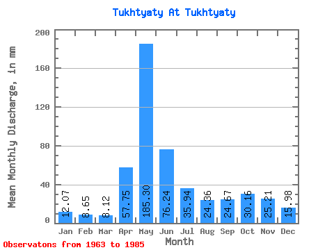
| Statistic | Jan | Feb | Mar | Apr | May | Jun | Jul | Aug | Sep | Oct | Nov | Dec | Annual |
|---|---|---|---|---|---|---|---|---|---|---|---|---|---|
| Mean | 12.07 | 8.72 | 8.12 | 57.75 | 185.28 | 76.24 | 35.94 | 24.35 | 24.67 | 30.16 | 25.21 | 15.97 | 502.26 |
| Standard Deviation | 5.47 | 3.84 | 2.82 | 32.30 | 79.44 | 43.20 | 17.22 | 10.86 | 14.15 | 16.00 | 14.18 | 8.22 | 130.34 |
| Min | 5.27 | 3.23 | 3.37 | 11.37 | 68.94 | 28.60 | 18.40 | 11.06 | 9.37 | 10.97 | 6.61 | 6.05 | 327.82 |
| Max | 27.99 | 17.71 | 14.25 | 119.57 | 419.84 | 221.57 | 87.25 | 52.87 | 72.07 | 66.00 | 56.69 | 38.79 | 792.05 |
| Coefficient of Variation | 0.45 | 0.44 | 0.35 | 0.56 | 0.43 | 0.57 | 0.48 | 0.45 | 0.57 | 0.53 | 0.56 | 0.52 | 0.26 |
 Return to R-Arctic Net Home Page