|
|
|||||||||||||||||
| Point ID: 8318 | Downloads | Plots | Site Data | Code: 9229 |
|
|
|||||||||||||||||
| Download | |
|---|---|
| Site Descriptor Information | Site Time Series Data |
| Link to all available data | |
| View: | Time Series | All |
| Units: | m3/s |
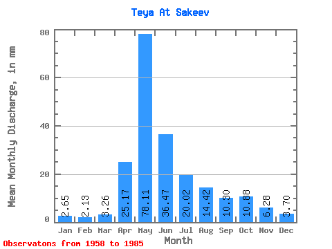
| Statistic | Jan | Feb | Mar | Apr | May | Jun | Jul | Aug | Sep | Oct | Nov | Dec | Annual |
|---|---|---|---|---|---|---|---|---|---|---|---|---|---|
| Mean | 2.65 | 2.15 | 3.26 | 25.17 | 78.10 | 36.47 | 20.01 | 14.42 | 10.30 | 10.88 | 6.28 | 3.70 | 212.33 |
| Standard Deviation | 1.19 | 1.86 | 1.78 | 11.82 | 35.92 | 22.32 | 15.09 | 7.09 | 3.88 | 4.79 | 3.35 | 1.41 | 61.62 |
| Min | 0.87 | 0.53 | 0.71 | 6.18 | 34.04 | 12.18 | 6.00 | 3.27 | 5.19 | 3.92 | 2.36 | 1.93 | 106.37 |
| Max | 5.81 | 10.18 | 9.18 | 46.93 | 193.62 | 93.86 | 77.39 | 35.00 | 19.42 | 23.18 | 15.29 | 8.45 | 390.72 |
| Coefficient of Variation | 0.45 | 0.86 | 0.55 | 0.47 | 0.46 | 0.61 | 0.75 | 0.49 | 0.38 | 0.44 | 0.53 | 0.38 | 0.29 |
 Return to R-Arctic Net Home Page