|
|
|||||||||||||||||
| Point ID: 8312 | Downloads | Plots | Site Data | Code: 9195 |
|
|
|||||||||||||||||
| Download | |
|---|---|
| Site Descriptor Information | Site Time Series Data |
| Link to all available data | |
| View: | Time Series | All |
| Units: | m3/s |
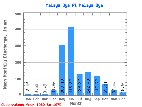
| Statistic | Jan | Feb | Mar | Apr | May | Jun | Jul | Aug | Sep | Oct | Nov | Dec | Annual |
|---|---|---|---|---|---|---|---|---|---|---|---|---|---|
| Mean | 12.16 | 9.72 | 9.48 | 31.82 | 303.13 | 413.77 | 129.25 | 142.50 | 117.67 | 69.04 | 32.00 | 18.52 | 1260.03 |
| Standard Deviation | 6.60 | 5.38 | 6.47 | 42.32 | 149.27 | 319.32 | 68.44 | 64.16 | 26.05 | 21.40 | 8.67 | 6.42 | 293.31 |
| Min | 4.83 | 4.24 | 3.16 | 5.76 | 81.83 | 135.00 | 55.79 | 33.48 | 84.60 | 44.63 | 19.80 | 11.16 | 847.63 |
| Max | 26.04 | 22.03 | 24.18 | 133.20 | 459.35 | 903.60 | 251.06 | 254.78 | 162.00 | 106.00 | 50.40 | 27.90 | 1698.54 |
| Coefficient of Variation | 0.54 | 0.55 | 0.68 | 1.33 | 0.49 | 0.77 | 0.53 | 0.45 | 0.22 | 0.31 | 0.27 | 0.35 | 0.23 |
 Return to R-Arctic Net Home Page