|
|
|||||||||||||||||
| Point ID: 8302 | Downloads | Plots | Site Data | Code: 9177 |
|
|
|||||||||||||||||
| Download | |
|---|---|
| Site Descriptor Information | Site Time Series Data |
| Link to all available data | |
| View: | Time Series | All |
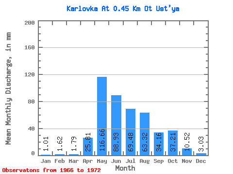
| Units: | m3/s |
| Statistic | Jan | Feb | Mar | Apr | May | Jun | Jul | Aug | Sep | Oct | Nov | Dec | Annual |
|---|---|---|---|---|---|---|---|---|---|---|---|---|---|
| Mean | 0.97 | 1.60 | 1.75 | 25.77 | 116.69 | 88.93 | 69.47 | 63.31 | 34.16 | 37.22 | 10.52 | 3.08 | 458.33 |
| Standard Deviation | 0.77 | 3.80 | 3.90 | 13.61 | 60.21 | 33.74 | 40.28 | 29.35 | 16.24 | 29.32 | 6.02 | 1.28 | 89.86 |
| Min | 0.22 | 0.00 | 0.00 | 6.83 | 58.27 | 33.62 | 25.77 | 23.53 | 10.85 | 7.06 | 3.80 | 1.68 | 312.85 |
| Max | 2.35 | 10.21 | 10.53 | 50.97 | 212.90 | 127.97 | 127.74 | 108.69 | 58.56 | 93.00 | 19.52 | 4.71 | 589.38 |
| Coefficient of Variation | 0.79 | 2.37 | 2.23 | 0.53 | 0.52 | 0.38 | 0.58 | 0.46 | 0.47 | 0.79 | 0.57 | 0.42 | 0.20 |
 Return to R-Arctic Net Home Page