|
|
|||||||||||||||||
| Point ID: 8299 | Downloads | Plots | Site Data | Code: 9169 |
|
|
|||||||||||||||||
| Download | |
|---|---|
| Site Descriptor Information | Site Time Series Data |
| Link to all available data | |
| View: | Time Series | All |
| Units: | m3/s |
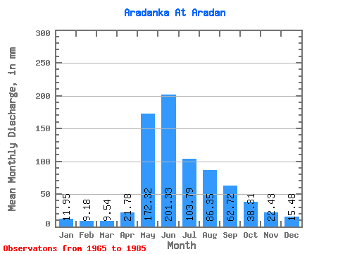
| Statistic | Jan | Feb | Mar | Apr | May | Jun | Jul | Aug | Sep | Oct | Nov | Dec | Annual |
|---|---|---|---|---|---|---|---|---|---|---|---|---|---|
| Mean | 11.95 | 9.25 | 9.54 | 21.78 | 172.29 | 201.33 | 103.77 | 86.34 | 62.72 | 38.31 | 22.43 | 15.47 | 752.32 |
| Standard Deviation | 3.00 | 2.32 | 2.18 | 11.76 | 53.39 | 92.79 | 44.87 | 27.31 | 16.89 | 7.06 | 4.65 | 3.83 | 127.94 |
| Min | 7.78 | 5.51 | 5.19 | 9.56 | 99.34 | 79.91 | 52.33 | 44.55 | 37.15 | 26.90 | 15.17 | 7.53 | 568.18 |
| Max | 18.51 | 13.72 | 13.57 | 48.26 | 302.36 | 420.45 | 243.12 | 150.56 | 94.00 | 59.85 | 30.94 | 23.82 | 978.31 |
| Coefficient of Variation | 0.25 | 0.25 | 0.23 | 0.54 | 0.31 | 0.46 | 0.43 | 0.32 | 0.27 | 0.18 | 0.21 | 0.25 | 0.17 |
 Return to R-Arctic Net Home Page