|
|
|||||||||||||||||
| Point ID: 8289 | Downloads | Plots | Site Data | Code: 9126 |
|
|
|||||||||||||||||
| Download | |
|---|---|
| Site Descriptor Information | Site Time Series Data |
| Link to all available data | |
| View: | Time Series | All |
| Units: | m3/s |
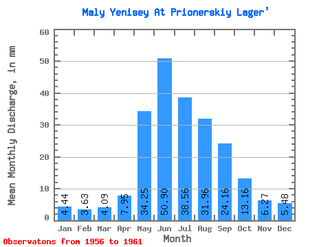
| Statistic | Jan | Feb | Mar | Apr | May | Jun | Jul | Aug | Sep | Oct | Nov | Dec | Annual |
|---|---|---|---|---|---|---|---|---|---|---|---|---|---|
| Mean | 4.44 | 3.66 | 4.09 | 7.95 | 34.24 | 50.90 | 38.55 | 31.95 | 24.16 | 13.16 | 6.27 | 5.48 | 221.95 |
| Standard Deviation | 0.71 | 0.73 | 0.54 | 2.83 | 6.44 | 9.22 | 11.12 | 9.22 | 4.30 | 1.04 | 0.75 | 0.33 | 37.48 |
| Min | 3.40 | 2.64 | 3.20 | 6.06 | 27.24 | 40.25 | 21.80 | 21.52 | 18.22 | 12.11 | 5.44 | 5.12 | 176.19 |
| Max | 5.07 | 4.33 | 4.71 | 13.62 | 43.05 | 65.46 | 52.55 | 45.47 | 30.34 | 14.30 | 6.94 | 5.99 | 258.36 |
| Coefficient of Variation | 0.16 | 0.20 | 0.13 | 0.36 | 0.19 | 0.18 | 0.29 | 0.29 | 0.18 | 0.08 | 0.12 | 0.06 | 0.17 |
 Return to R-Arctic Net Home Page