|
|
|||||||||||||||||
| Point ID: 8285 | Downloads | Plots | Site Data | Code: 9035 |
|
|
|||||||||||||||||
| Download | |
|---|---|
| Site Descriptor Information | Site Time Series Data |
| Link to all available data | |
| View: | Time Series | All |
| Units: | m3/s |
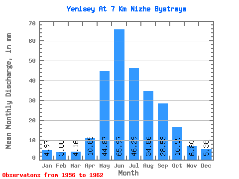
| Statistic | Jan | Feb | Mar | Apr | May | Jun | Jul | Aug | Sep | Oct | Nov | Dec | Annual |
|---|---|---|---|---|---|---|---|---|---|---|---|---|---|
| Mean | 4.97 | 3.91 | 4.16 | 10.85 | 44.87 | 65.97 | 46.28 | 34.86 | 28.53 | 16.58 | 6.80 | 5.38 | 272.31 |
| Standard Deviation | 0.63 | 0.50 | 0.71 | 5.02 | 9.23 | 9.37 | 11.12 | 7.40 | 4.65 | 1.44 | 0.79 | 0.50 | 32.84 |
| Min | 4.08 | 3.03 | 3.25 | 7.36 | 33.35 | 51.38 | 30.61 | 27.02 | 20.94 | 15.18 | 6.09 | 4.52 | 239.69 |
| Max | 5.62 | 4.42 | 5.25 | 21.99 | 59.90 | 76.83 | 59.30 | 45.07 | 33.90 | 19.49 | 8.36 | 5.88 | 326.58 |
| Coefficient of Variation | 0.13 | 0.13 | 0.17 | 0.46 | 0.21 | 0.14 | 0.24 | 0.21 | 0.16 | 0.09 | 0.12 | 0.09 | 0.12 |
 Return to R-Arctic Net Home Page