|
|
|||||||||||||||||
| Point ID: 8282 | Downloads | Plots | Site Data | Code: 9012 |
|
|
|||||||||||||||||
| Download | |
|---|---|
| Site Descriptor Information | Site Time Series Data |
| Link to all available data | |
| View: | Time Series | All |
| Units: | m3/s |
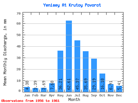
| Statistic | Jan | Feb | Mar | Apr | May | Jun | Jul | Aug | Sep | Oct | Nov | Dec | Annual |
|---|---|---|---|---|---|---|---|---|---|---|---|---|---|
| Mean | 4.38 | 3.42 | 3.69 | 7.68 | 36.20 | 62.62 | 45.36 | 35.68 | 29.18 | 16.17 | 6.91 | 5.41 | 255.89 |
| Standard Deviation | 0.48 | 0.42 | 0.42 | 3.41 | 6.61 | 5.39 | 12.07 | 7.24 | 2.62 | 0.78 | 0.79 | 0.64 | 31.04 |
| Min | 3.66 | 2.92 | 3.19 | 5.55 | 27.40 | 53.65 | 27.56 | 27.71 | 24.71 | 15.38 | 6.18 | 4.39 | 222.72 |
| Max | 4.86 | 4.07 | 4.22 | 14.51 | 44.06 | 67.36 | 57.14 | 45.00 | 31.95 | 17.44 | 8.23 | 6.12 | 293.81 |
| Coefficient of Variation | 0.11 | 0.12 | 0.12 | 0.44 | 0.18 | 0.09 | 0.27 | 0.20 | 0.09 | 0.05 | 0.11 | 0.12 | 0.12 |
 Return to R-Arctic Net Home Page