|
|
|||||||||||||||||
| Point ID: 8277 | Downloads | Plots | Site Data | Code: 8403 |
|
|
|||||||||||||||||
| Download | |
|---|---|
| Site Descriptor Information | Site Time Series Data |
| Link to all available data | |
| View: | Time Series | All |
| Units: | m3/s |
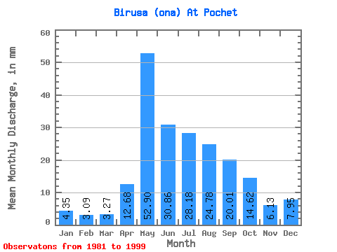
| Statistic | Jan | Feb | Mar | Apr | May | Jun | Jul | Aug | Sep | Oct | Nov | Dec | Annual |
|---|---|---|---|---|---|---|---|---|---|---|---|---|---|
| Mean | 4.35 | 3.12 | 3.27 | 12.68 | 52.89 | 30.86 | 28.18 | 24.78 | 20.01 | 14.62 | 6.13 | 7.95 | 207.66 |
| Standard Deviation | 0.82 | 0.64 | 0.49 | 9.19 | 23.31 | 9.53 | 13.48 | 12.26 | 6.94 | 3.92 | 1.32 | 10.57 | 51.61 |
| Min | 2.70 | 1.92 | 2.28 | 4.03 | 19.21 | 14.80 | 11.27 | 13.02 | 10.96 | 9.58 | 3.86 | 3.86 | 108.05 |
| Max | 5.56 | 4.25 | 4.05 | 34.83 | 111.14 | 52.25 | 68.27 | 59.28 | 34.78 | 23.82 | 7.68 | 48.80 | 327.37 |
| Coefficient of Variation | 0.19 | 0.20 | 0.15 | 0.72 | 0.44 | 0.31 | 0.48 | 0.49 | 0.35 | 0.27 | 0.22 | 1.33 | 0.25 |
 Return to R-Arctic Net Home Page