|
|
|||||||||||||||||
| Point ID: 8272 | Downloads | Plots | Site Data | Code: 8389 |
|
|
|||||||||||||||||
| Download | |
|---|---|
| Site Descriptor Information | Site Time Series Data |
| Link to all available data | |
| View: | Time Series | All |
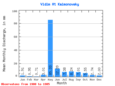
| Units: | m3/s |
| Statistic | Jan | Feb | Mar | Apr | May | Jun | Jul | Aug | Sep | Oct | Nov | Dec | Annual |
|---|---|---|---|---|---|---|---|---|---|---|---|---|---|
| Mean | 1.91 | 0.96 | 0.71 | 3.01 | 85.31 | 12.39 | 7.38 | 8.24 | 7.01 | 5.55 | 2.74 | 2.00 | 169.85 |
| Standard Deviation | 1.52 | 1.31 | 0.91 | 1.94 | 40.69 | 6.01 | 4.13 | 5.17 | 2.86 | 2.42 | 1.58 | 1.01 | 32.22 |
| Min | 0.30 | 0.00 | 0.00 | 0.96 | 22.65 | 5.41 | 2.22 | 3.29 | 4.22 | 2.68 | 1.33 | 1.15 | 132.71 |
| Max | 4.05 | 2.79 | 1.91 | 4.81 | 123.95 | 20.07 | 13.24 | 16.76 | 12.44 | 9.79 | 5.70 | 3.60 | 190.26 |
| Coefficient of Variation | 0.80 | 1.36 | 1.29 | 0.64 | 0.48 | 0.48 | 0.56 | 0.63 | 0.41 | 0.43 | 0.58 | 0.50 | 0.19 |
 Return to R-Arctic Net Home Page