|
|
|||||||||||||||||
| Point ID: 8263 | Downloads | Plots | Site Data | Code: 8373 |
|
|
|||||||||||||||||
| Download | |
|---|---|
| Site Descriptor Information | Site Time Series Data |
| Link to all available data | |
| View: | Time Series | All |
| Units: | m3/s |
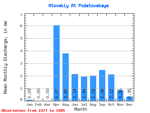
| Statistic | Jan | Feb | Mar | Apr | May | Jun | Jul | Aug | Sep | Oct | Nov | Dec | Annual |
|---|---|---|---|---|---|---|---|---|---|---|---|---|---|
| Mean | 0.07 | 0.00 | 0.00 | 6.07 | 3.82 | 2.13 | 1.93 | 2.07 | 2.51 | 2.13 | 0.83 | 0.37 | 22.55 |
| Standard Deviation | 0.19 | 0.00 | 0.00 | 3.24 | 1.94 | 1.47 | 1.65 | 1.85 | 3.46 | 2.46 | 1.30 | 0.75 | 11.06 |
| Min | 0.00 | 0.00 | 0.00 | 2.40 | 1.24 | 0.51 | 0.44 | 0.35 | 0.34 | 0.27 | 0.00 | 0.00 | 6.16 |
| Max | 0.53 | 0.00 | 0.00 | 12.15 | 6.72 | 4.19 | 4.95 | 4.60 | 11.38 | 8.13 | 3.17 | 1.86 | 37.50 |
| Coefficient of Variation | 2.83 | 0.53 | 0.51 | 0.69 | 0.85 | 0.90 | 1.38 | 1.16 | 1.57 | 2.00 | 0.49 |
 Return to R-Arctic Net Home Page