|
|
|||||||||||||||||
| Point ID: 8254 | Downloads | Plots | Site Data | Code: 8349 |
|
|
|||||||||||||||||
| Download | |
|---|---|
| Site Descriptor Information | Site Time Series Data |
| Link to all available data | |
| View: | Time Series | All |
| Units: | m3/s |
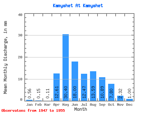
| Statistic | Jan | Feb | Mar | Apr | May | Jun | Jul | Aug | Sep | Oct | Nov | Dec | Annual |
|---|---|---|---|---|---|---|---|---|---|---|---|---|---|
| Mean | 0.53 | 0.16 | 0.13 | 12.61 | 30.38 | 18.00 | 12.47 | 13.57 | 10.88 | 7.79 | 2.31 | 0.99 | 113.37 |
| Standard Deviation | 0.43 | 0.17 | 0.23 | 14.48 | 12.71 | 9.49 | 12.88 | 14.27 | 10.00 | 6.34 | 2.02 | 0.55 | 61.34 |
| Min | 0.00 | 0.00 | 0.00 | 0.79 | 8.91 | 5.17 | 3.95 | 3.40 | 1.99 | 2.62 | 0.00 | 0.06 | 60.91 |
| Max | 1.17 | 0.46 | 0.61 | 37.22 | 47.88 | 35.57 | 45.10 | 46.77 | 31.79 | 21.16 | 7.04 | 1.59 | 230.15 |
| Coefficient of Variation | 0.81 | 1.01 | 1.80 | 1.15 | 0.42 | 0.53 | 1.03 | 1.05 | 0.92 | 0.81 | 0.87 | 0.56 | 0.54 |
 Return to R-Arctic Net Home Page