|
|
|||||||||||||||||
| Point ID: 8252 | Downloads | Plots | Site Data | Code: 8342 |
|
|
|||||||||||||||||
| Download | |
|---|---|
| Site Descriptor Information | Site Time Series Data |
| Link to all available data | |
| View: | Time Series | All |
| Units: | m3/s |
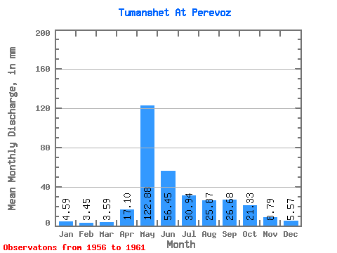
| Statistic | Jan | Feb | Mar | Apr | May | Jun | Jul | Aug | Sep | Oct | Nov | Dec | Annual |
|---|---|---|---|---|---|---|---|---|---|---|---|---|---|
| Mean | 4.59 | 3.48 | 3.59 | 17.10 | 122.86 | 56.45 | 30.93 | 25.86 | 26.68 | 21.33 | 8.79 | 5.57 | 309.73 |
| Standard Deviation | 1.55 | 0.99 | 1.13 | 12.39 | 25.01 | 4.73 | 14.40 | 11.25 | 12.75 | 12.59 | 3.19 | 1.50 | 27.31 |
| Min | 2.86 | 1.90 | 1.59 | 7.07 | 92.29 | 52.94 | 20.55 | 15.29 | 14.25 | 9.46 | 6.25 | 3.90 | 280.30 |
| Max | 6.62 | 4.43 | 4.61 | 41.26 | 157.96 | 63.57 | 58.88 | 45.07 | 47.29 | 41.90 | 13.76 | 7.36 | 336.64 |
| Coefficient of Variation | 0.34 | 0.28 | 0.32 | 0.72 | 0.20 | 0.08 | 0.47 | 0.43 | 0.48 | 0.59 | 0.36 | 0.27 | 0.09 |
 Return to R-Arctic Net Home Page