|
|
|||||||||||||||||
| Point ID: 8248 | Downloads | Plots | Site Data | Code: 8322 |
|
|
|||||||||||||||||
| Download | |
|---|---|
| Site Descriptor Information | Site Time Series Data |
| Link to all available data | |
| View: | Time Series | All |
| Units: | m3/s |
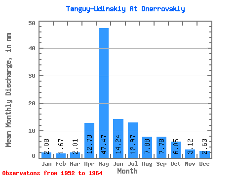
| Statistic | Jan | Feb | Mar | Apr | May | Jun | Jul | Aug | Sep | Oct | Nov | Dec | Annual |
|---|---|---|---|---|---|---|---|---|---|---|---|---|---|
| Mean | 2.08 | 1.69 | 2.01 | 12.73 | 47.46 | 14.24 | 12.96 | 7.88 | 7.78 | 6.05 | 3.12 | 2.63 | 109.63 |
| Standard Deviation | 0.59 | 0.78 | 0.83 | 16.61 | 16.56 | 8.67 | 7.90 | 5.30 | 6.75 | 3.13 | 1.58 | 0.86 | 29.58 |
| Min | 1.30 | 0.00 | 0.00 | 1.40 | 19.50 | 5.42 | 3.86 | 3.45 | 3.40 | 3.31 | 1.72 | 1.21 | 64.39 |
| Max | 3.11 | 3.17 | 3.50 | 52.04 | 78.70 | 37.94 | 23.39 | 18.98 | 26.91 | 12.52 | 7.30 | 4.12 | 166.50 |
| Coefficient of Variation | 0.28 | 0.47 | 0.41 | 1.30 | 0.35 | 0.61 | 0.61 | 0.67 | 0.87 | 0.52 | 0.51 | 0.33 | 0.27 |
 Return to R-Arctic Net Home Page